Join Nature Notes-What are you or have you seen and enjoyed in nature? It can be from your own backyard, the local park, out on a hike or anywhere. What plants and animals catch your interest? Do you garden? Have you read a good book on nature?
Join Nature Notes-What are you or have you seen and enjoyed in nature? It can be from your own backyard, the local park, out on a hike or anywhere. What plants and animals catch your interest? Do you garden? Have you read a good book on nature?
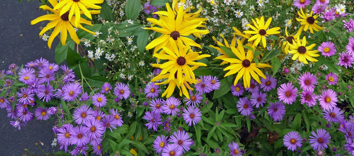
We are at peak fall colors now but it has rained and rained and rained so I am not able to sit outside and really enjoy it…Here is a photo captured in between the rainy days….
Have a wonderful nature-filled week! Please be safe.
Join Nature Notes-What are you or have you seen and enjoyed in nature? It can be from your own backyard, the local park, out on a hike or anywhere. What plants and animals catch your interest? Do you garden? Have you read a good book on nature?
— Into fall now. Coldish rainy days and the leaves are falling……
This is a very geeky post but I do love this stuff…….
Doppler Radar Can Pick Up Birds, Butterflies and Bugs!!
Doppler weather radar is one of the most useful tools available to track the weather in almost real time. Since the technology came into regular use in the 1950s, researchers have made incredible advances in the abilities of basic weather radar. Not only does weather radar track precipitation, but it can also detect bugs, bats, dust, road traffic, tornado debris, and even the setting sun.
Doppler radar works by sending out a beam of microwave radiation across the horizon at a slight tilt (between 0.5 and 19.5 degrees of tilt, depending on the weather that day) that bounces off of objects and returns to the radar site. The speed and intensity of the return pulse tells the radar how far away and how intense the precipitation is. The result is called a “radar return,” and these returns are translated into a color-coded gradient that you see on a radar image when you check for storms in your area.
I love weather and when I was a child wanted to be a meteorologist so this information was too much fun not to pass on incase you love weather too….
Meteorologists at the National Weather Service (NWS) in Boulder, Colorado, spotted something unusual when checking Doppler radar on what was an otherwise calm weather day.
At first, the NWS meteorologists thought the radar echoes spreading from east to west across the Colorado Front Range, including the Denver metro area, were birds. Observing birds on radar is a fairly common occurrence, especially when they take flight early in the morning.
But after some additional investigation, the mystery of what the radar was sensing pointed to another culprit: migrating butterflies.
Painted Lady Butterfly
You can see the radar echoes in purple (left side) and blue (right side) advancing from right to left in the animation below (originally labeled as birds). The NWS estimated that the swath of butterflies was more than 70 miles wide, extending across all of Arapahoe County.
There was ground truth to prove that butterflies were the cause of the radar echoes based on photo reports from social media. Several tweets described seeing dozens of painted lady butterflies in yards of Denver metro residents Tuesday.
The NWS said that insects rarely produce such a well-defined radar signature as they saw on Tuesday, which led to the initial hunch that they were seeing birds.
This case was different, however, since butterflies have larger wings than a typical insect and the fact that they were highly concentrated as they flew with the wind flow at that time. Those two factors made them a big enough target for the radar to detect in a vivid manner.
This isn’t the only non-weather feature radar can detect. Here are other things radar has picked up.
Grasshoppers and Beetles
Grasshoppers and beetles detected by radar near the border between Texas and Oklahoma on July 22, 2015.
The green and yellow radar echoes in this image from July 22, 2015, show grasshoppers and beetles detected by radar near the border between Texas and Oklahoma, according to a tweet sent by the NWS office in Norman, Oklahoma. Since the radar is very sensitive, you would not see a huge swarm at ground level, the NWS said.
Monarch Butterfly Migration
(National Weather Service Reno, Nevada)
The NWS office in Reno, Nevada, posted to Twitter on March 27, 2015, the radar image above that shows the spring migration of Monarch butterflies. These butterflies were spotted using a differential reflectivity scan, which is typically used to identify different types of precipitation, hail size and tornadic debris. As shown in the example above, it can also identify non-meteorological echoes such as birds and insects. In this case, the NWS says the differential reflectivity shows objects that are much wider than they are taller, or what you would expect from the body type of a butterfly.
Birds Inside the Eye of Hurricane Hermine
As Hurricane Hermine made landfall along Florida’s Gulf coast in early September 2016, radar detected an interesting phenomenon: birds trapped flying inside the calm eye of Hermine.
Base reflectivity (left) and Differential reflectivity (right) radar images of Hermine at 10:38 p.m. EDT on Sept. 1. The red shaded area on the image to the right shows the birds swirling inside Hermine’s eye just before landfall.
The birds were detected using differential reflectivity from NOAA’s Dual-Polarization radar. This particular radar feature can be used to detect non-meteorological radar echoes such as birds and insects, in addition to its normal precipitation detection function.
We’ve seen this occur one other time in recent years during another U.S. hurricane landfall. Birds were detected on radar in the eye of Arthur as it moved near the coast of North Carolina in 2014.
Mayfly Hatch
Mayfly hatch on July 26, 2016.
(National Weather Service La Crosse, Wisconsin.)
At some point during the summer every year, the Doppler radar at the NWS in La Crosse, Wisconsin, lights up with echoes, indicating that a mayfly hatch has occurred.
You can see the recent hatch in the image above in the green echoes from near the label for the city of La Crosse southward along the river.
The Bat Signal
Circled are the emerging colonies of bats heading out to feed on insects June 13, 2016. (NWS-San Antonio)
This image was posted by the NWS in San Antonio, Texas, on June 13, 2016 with a caption “The Bat Signal is strong tonight!”
Each circle on the map shows an emerging bat colony detected by radar as they depart for the evening to feast on insects. This is a common summertime occurrence in central Texas.
Sometimes, bats even exit their caves in waves like seen here north of San Antonio as concentric rings.
Birds Along Nebraska’s Platte River
This radar image from March 2, 2016, shows birds that were observed by radar along the Platte River in Nebraska. The birds are represented by the green and blue shadings near the red line, which is Interstate 80 along the Platte River in central Nebraska. Video taken the previous day verified the existence of a large number of sandhill cranes in the area, according to a Facebook post by the Rowe Sanctuary.
Grasshoppers and Beetles
Grasshoppers and beetles detected by radar near the border between Texas and Oklahoma on July 22, 2015.
The green and yellow radar echoes in this image from July 22, 2015, show grasshoppers and beetles detected by radar near the border between Texas and Oklahoma, according to a tweet sent by the NWS office in Norman, Oklahoma. Since the radar is very sensitive, you would not see a huge swarm at ground level, the NWS said.
Birds Migrating
Radar loop shows bird migration on April 12, 2012. Image credit: NOAA
Niziol says, “On the animation above I have penciled in what I describe as ‘bird front’ to outline the leading edge of the bird migration as it heads from the south shores of both Lakes Erie and Ontario across the water just after sunset.”
You can read Tom’s full article on this subject here.
Have a wonderful nature-filled week! Please be safe.